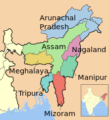
Manipur is a state in northeastern India, with the city of Imphal as its capital. Manipur is sometimes called alternative names such as Kangleipak or Sanaleibak. It is bounded by Nagaland to the north, Mizoram to the south, and Assam to the west; Burma (Myanmar) lies to its east. The state covers an area of 22,327 square kilometres (8,621 sq mi) and has a population of almost 3 million, including the Meetei, Kuki, Naga, and Pangal peoples, who speak Sino-Tibetan languages. Manipur has been at the crossroads of Asian economic and cultural exchange for more than 2,500 years.It has long connected the Indian subcontinent to Southeast Asia, enabling migration of people, cultures and religions.
During the British Rule, the Kingdom of Manipur was one of the princely states.Between 1917 and 1939, the people of Manipur pressed for their rights against the British Rule. By the late 1930s, the princely state of Manipur negotiated with the British administration its preference to be part of India, rather than Burma.These negotiations were cut short with the outbreak of World War II. On 21 September 1949, Maharaja Budhachandra signed a Treaty of Accession merging the kingdom into India. This merger is disputed by groups in Manipur as having been completed without consensus and under duress. The dispute and differing visions for the future has resulted in a 50-year insurgency in the state for independence from India, as well as in violence between ethnic groups in the state. Over 2010–2013, the militant insurgency was responsible for the violent death of about 1 civilian per 100,000 people, each year.The world average annual death rate from intentional violence has been 7.9 per 100,000 people.
The Meetei ethnic group,represents 53% of the population of Manipur state. The main language of the state is Meeteilon (Manipuri). By comparison, indigenous tribal peoples constitute 20% of the state population; they are distinguished by dialects and culture that are often village-based. Manipur’s ethnic groups practice a variety of religions.According to 2011 census, Hinduism is the major religion in the state closely followed by Christianity. Other religions include Islam, Sanamahism, Buddhism etc.
Manipur has primarily an agrarian economy, with significant hydroelectric power generation potential. It is connected to other areas by daily flights through Imphal airport, the second largest in northeastern India. Manipur is home to many sports, the origin of Manipuri dance,and credited with introducing polo to Europeans. [1]
Tripura is a state in Northeast India. The third-smallest state in the country, it covers 10,491 km2 (4,051 sq mi) and is bordered by Bangladesh (East Bengal) to the north, south, and west, and the Indian states of Assam and Mizoram to the east. In 2011 the state had 3,671,032 residents, constituting 0.3% of the country’s population. The Bengali Hindu people form the ethno-linguistic majority in Tripura. Indigenous communities, known in India as scheduled tribes, form about 30 per cent of Tripura’s population. The Kokborok speaking Tripuri people are the major group among 19 tribes and many subtribes.
The area of modern ‘Tripura’ was ruled for several centuries by the Tripuri dynasty. It was the independent princely state of the Tripuri Kingdom under the protectorate of the British Empire which was known as Hill Tippera while the area annexed and ruled directly by British India was known as Tippera District (present Comilla District).The independent Tripuri Kingdom (or Hill Tippera) joined the newly independent India in 1949. Ethnic strife between the indigenous Tripuri people and the migrant Bengali population due to large influx of Bengali Hindu refugees and settlers from Bangladesh (former East Pakistan) led to tension and scattered violence since its integration into the country of India, but the establishment of an autonomous tribal administrative agency and other strategies have led to peace.
Tripura lies in a geographically disadvantageous location in India, as only one major highway, the National Highway 8, connects it with the rest of the country. Five mountain ranges—Boromura, Atharamura, Longtharai, Shakhan and Jampui Hills—run north to south, with intervening valleys; Agartala, the capital, is located on a plain to the west. The state has a tropical savanna climate, and receives seasonal heavy rains from the south west monsoon. Forests cover more than half of the area, in which bamboo and cane tracts are common. Tripura has the highest number of primate species found in any Indian state. Due to its geographical isolation, economic progress in the state is hindered. Poverty and unemployment continue to plague Tripura, which has a limited infrastructure. Most residents are involved in agriculture and allied activities, although the service sector is the largest contributor to the state’s gross domestic product.
Mainstream Indian cultural elements, especially from Bengali culture, coexist with traditional practices of the ethnic groups, such as various dances to celebrate religious occasions, weddings and festivities; the use of locally crafted musical instruments and clothes; and the worship of regional deities. The sculptures at the archaeological sites Unakoti, Pilak and Devtamura provide historical evidence of artistic fusion between organised and tribal religions. The Ujjayanta Palace in Agartala was the former royal abode of the Tripuri king.[2]
Meghalaya is a state in northeast India. The name means “the abode of clouds” in Sanskrit. The population of Meghalaya as of 2016 is estimated to be 3,211,474.Meghalaya covers an area of approximately 22,430 square kilometers, with a length to breadth ratio of about 3:1.
The state is bounded to the south by the Bangladeshi divisions of Mymensingh and Sylhet, to the west by the Bangladeshi division of Rangpur, and to the east by India’s State of Assam. The capital of Meghalaya is Shillong. During the British occupation of India, the British imperialist authorities nicknamed it the “Scotland of the East”.Meghalaya was previously part of Assam, but on 21 January 1972, the districts of Khasi, Garo and Jaintia hills became the new state of Meghalaya. English is the official language of Meghalaya. The other principal languages spoken include Khasi, Pnar and Garo. Unlike many Indian states, Meghalaya has historically followed a matrilineal system where the lineage and inheritance are traced through women; the youngest daughter inherits all wealth and she also takes care of her parents.
The state is the wettest region of India, recording an average of 12,000 mm (470 in) of rains a year.About 70% of the state is forested.The Meghalaya subtropical forests ecoregion encompasses the state; its mountain forests are distinct from the lowland tropical forests to the north and south. The forests are notable for their biodiversity of mammals, birds, and plants.
Meghalaya has predominantly an agrarian economy with a significant commercial forestry industry. The important crops are potatoes, rice, maize, pineapples, bananas, papayas, spices, etc. The service sector is made up of real estate and insurance companies. Meghalaya’s gross state domestic product for 2012 was estimated at ₹16,173 crore (US$2.4 billion) in current prices.The state is geologically rich in minerals, but it has no significant industries.The state has about 1,170 km (730 mi) of national highways. It is also a major logistical center for trade with Bangladesh.[3]
(Ref:[1]https://en.wikipedia.org/wiki/Manipur,[2]https://en.wikipedia.org/wiki/Tripura, [3]https://en.wikipedia.org/wiki/Meghalaya)